
FS-2024-0705 | July 2024
An Overview of Drones in Agriculture
Introduction
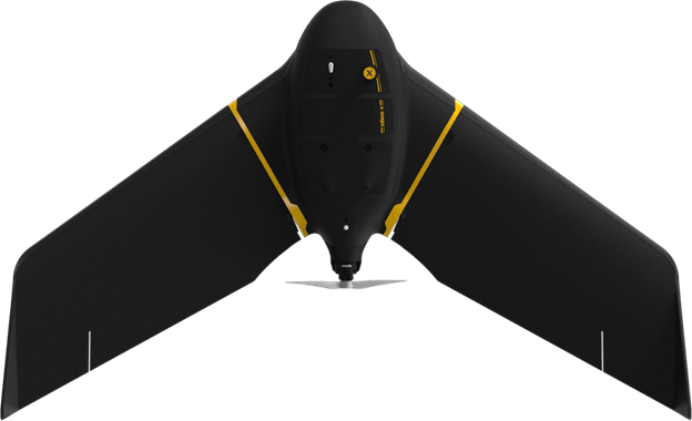
Drones, also known as small Unmanned Aerial Systems (sUAS) or Unmanned Aerial Vehicles (UAVs), are defined as aircraft without any human pilot, crew, or passengers on board. For a drone to successfully take off, fly, and land, it requires a mix of hardware and software components. An operator has an option to add or mount an operational system to drone such as a Raspberry Pi computer that receives the commands from a ground controller. This allows drones for automation of certain data processing tasks such as weed detection in real-time during flight. Drones are generally controlled by ground control stations and have sensors, gyroscopes (for stability), navigation systems, and rotors or fixed wings. Drones are tools that can complete certain functions depending on the user’s interests. The technology allows operators to direct drones to perform complex tasks in agriculture, ranging from precise crop monitoring to efficient resource management, paving the way for a new era of precision agriculture.
The use of drones to increase crop yield and reduce input costs by corn, soybean, and wheat farmers could save an estimated $1.3 billion annually (Doering, 2015). This significant budgetary impact illustrates the potential of drone use not only in enhancing agricultural efficiency but also in contributing to the economic viability of farming in the modern agriculture. This publication explores how drone technology is transforming agricultural practices, enhancing crop productivity, and offering sustainable solutions to farming challenges, while also touching on the limitations and challenges that come with drones in agriculture. This will provide readers with a thorough understanding of the utility of this cutting-edge application of technology in contemporary farming.
Components of a drone
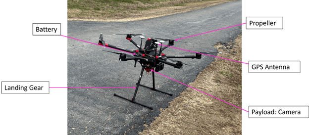
Drones come in various sizes and configurations. Most include the following features:
- Battery: The battery provides power for the drone’s functions, enabling all functions from propulsion to navigation. For most drones, the battery life dictates the length of flight time available before recharging or replacement is necessary.
- Propeller: Propellers are crucial for the drone's movement and stability. In copter drones, propellers generate lift by spinning at high speeds, allowing operators to direct the drone to ascend, descend, and maneuver through the air. In fixed wing drones, the propellers primarily provide thrust, while the wings generate the lift necessary for flight.
- GPS Antenna: The GPS antenna helps operators determine the drone’s position relative to the Earth's surface. This positioning is vital for navigation, enabling stable flight paths and precise location tracking for tasks like mapping or targeted spraying.
- Payload: The payload of a drone refers to any equipment that the drone carries to perform specific tasks. Common payloads include cameras for capturing images or video, sensors for collecting environmental data, and sprayers for agricultural applications.
- Landing Gear: The landing gear supports the drone during takeoff and landing. It is designed to absorb the shock of landing, protecting the drone's body and payload. For some models, operators can retract the landing gear during flight to reduce drag.
Evolution of drone use in agriculture
In 1921, the USDA along with the US Army used manned aircraft for aerial spraying, which combined two emerging technologies to combat pests in agriculture (AgAir Update, 2021). The use of drones in agriculture made a real breakthrough in agriculture in approximately 2011 due to the increased affordability and technological advancements, such as lightweight cameras and sensors (Frankelius et al., 2024). These conditions have led to a rise in the use of drones for a variety of agricultural applications, such as crop health monitoring, irrigation, weed and disease detection, water and nutrient stress measurements, and monitoring livestock conditions (Veroustraete, 2015).
As technology continues to advance, the use of drones in agriculture will continue to evolve, offering farmers new and innovative ways to improve efficiency and crop yields. The use of drones has significantly advanced agriculture through the development of precision spraying systems and the integration of artificial intelligence and machine learning. These technologies assist farmers with intelligent and real-time decision-making. The rise in drone applications in agriculture indicates that farmers support the use of drones for a variety of uses. These include monitoring crop growth, early disease detection through crop color changes, cover crop sowing, pesticide or fertilizer spraying, management zone delineation, and optimizing irrigation (Semantic AgriTech, 2023). These innovations have contributed to more efficient use of resources as well as reduced environmental impact. For instance, the integration of artificial intelligence and machine learning algorithms enables drones to collect crop health data and help farmers to provide actionable insights, ultimately leading to more informed decision-making and improved crop yields. Furthermore, the use of drones for precision spraying has the potential to minimize both chemical usage and the risk of over-spraying, thereby providing technology-driven smart agricultural practices and economic benefits to farmers. As drone technology continues to advance, drones will play an increasingly significant role in the agricultural industry, creating a new agricultural revolution and contributing to the optimization of resource utilization and the reduction of environmental impact (Ren et al., 2020).
Benefits and challenges of drones in agriculture
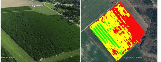
As the use of drones in agriculture continues to grow, its benefits and challenges become more prevalent. Their use can help enhance agricultural output and on-farm expertise, as well as save money and improve operational efficiency and profitability (Rejeb et al., 2022). Drones can also be used for better crop monitoring, scouting, and control (Naji, 2019). Operators can use drones to offer an alternative viewpoint, support efficient planning, and generate important data including mapping, plant health data, elevation data, and orthomosaic images (detailed aerial views created by stitching together multiple photos taken from drones to form a single, large-format map) (McCarthy et al., 2023).
However, there are many challenges associated with drone usage, such as cost concerns, certification requirements to operate drones, lack of experience in interpreting data generated by drones, and managing profit margins. These factors make some farmers hesitant to use drones (McCarthy et al., 2023). The initial investment in drone technology can be substantial, not only financially but also in terms of the time required to learn and effectively integrate this technology into regular farming operations. Moreover, the actual return on this investment can vary, depending on several factors including crop yield improvements and cost savings in areas such as resource management and monitoring through the use of drones. Despite these challenges, the potential benefits of using drones in agriculture are significant, and ongoing research and development is focused on maximizing the advantages while addressing the associated limitations.
Examples of agricultural operations using drones
Drones have become invaluable tools in modern agriculture, offering precision, efficiency, and real-time data collection. Here are some key agricultural operations where drones are making a significant impact:
- Crop scouting: Operators can use drones to quickly survey and report on crop health across vast areas, identifying issues like pest infestations or nutrient deficiencies earlier than traditional methods.
- Stand Count: Stand counts are also known as plant counts. Operators can use drones to quickly survey and report the number of plants across vast areas, doing this more efficiently compared to counting plants one-by-one with traditional methods.
- Spraying: Operators can use drones to spray pesticides or fertilizers more precisely and quickly than ground-based methods, reducing runoff and increasing the effectiveness of these inputs.
- Cover crop seeding: Operators can use drones to plant seeds at a faster rate and with less labor than traditional methods, which is especially useful in difficult-to-access areas. Drones can be used to seed cover crops in any field with standing conditions.
- Crop yield estimation: By analyzing drone-captured data, farmers can predict yield with greater accuracy, which aids in market planning and resource allocation.
- Irrigation management: Operators can use drones to help design more efficient irrigation systems and ensure that water distribution is even across all crops. Data collected using drones can provide information to generate irrigation management zones.
- Plant disease assessment: Operators can use drones to monitor plants for signs of disease, allowing for targeted treatment that minimizes chemical use and maximizes crop health.
- Water stress assessment: Operators can use drones equipped with multispectral sensors to identify areas of water stress in crops by analyzing how plants absorb and reflect different wavelengths of light, aiding in more precise irrigation management.
- Nutrient stress assessment: By capturing spectral data, drones assist operators in identifying areas with potential nutrient deficiencies, guiding precision fertilization.
- Weed stress assessment: Operators can use drones to spot weed outbreaks, allowing for precise herbicide application, reducing costs and environmental impact.
- Field topography: Operators can use high-resolution drone images to assist in planning field operations and optimizing best management strategies based on changes in topography.
- Soil mapping: Operators can use drones equipped with specialized sensors to create detailed maps of soil characteristics, helping to optimize inputs like seeds and fertilizers.
Conclusion
The use of drones has made a significant impact on the agricultural industry in the last decade and will continue to do so in the coming years. The use of drones in agriculture comes with both challenges and benefits, especially as drone usage increases in the future. The potential benefits that come with increased usage will lead to more research to explore new applications of the technology while also aiming to reduce their current limitations.
References
- AgAir Update. (2021, August 2). A Century of Agricultural Aviation — 1921-2021. https://agairupdate.com/2021/08/02/a-century-of-agricultural-aviation-1921-2021/
- Doering, C. (2015, July 21). Drones could save farmers millions, study finds. The Des Moines Register. https://www.desmoinesregister.com/story/money/ agriculture/2015/07/21/drones-farm-savings-agriculture-millions/30486487/
- Frankelius, P., Norrman, C., & Johansen, K. (2024, January 16). Drones: The airtech revolution agriculture. DLG Agrifuture Magazine. https://www.dlg.org/en/agriculture/topics/dlg-agrifuture-magazine/knowledge-skills/drones-the-airtech-revolution-agriculture
- McCarthy, C., Nyoni, H. K., Kachamba, D. J., Banda, B., Banfill, J., & Hoshino, B. (2023). Can Drones Help Smallholder Farmers Improve Agriculture Efficiencies and Reduce Food Insecurity in Sub-Saharan Africa? Local Perceptions from Malawi. Agriculture, 13(5), 1075. https://doi.org/10.3390/agriculture13051075
- Naji, I. (2019). The Drones' Impact On Precision Agriculture [Master's thesis, University of Texas at El Paso]. University of Texas at El Paso ScholarWorks. https://digitalcommons.utep.edu/open_etd/2880
- Rejeb, A., Abdollahi, A., Rejeb, K., & Treiblmaier, H. (2022). Drones in agriculture: A review and bibliometric analysis. Computers and Electronics in Agriculture, 198, 107017. https://doi.org/10.1016/j.compag.2022.107017
- Ren, Q., Zhang, R., Cai, W., Sun, X., & Cao, L. (2020). Application and Development of New Drones in Agriculture. IOP Conference Series: Earth and Environmental Science, 440(5), Article 052041. https://doi.org/10.1088/1755-1315/440/5/052041
- Semantic Agri Tech (2022, December 5). Future Of Drones In Agriculture In India: How Is It Changing The Future Of Agriculture? https://semantictech.in/blogs/future -of-drones-in-agriculture-in-india/
- Veroustraete, F. (2015). The Rise of the Drones in Agriculture. EC Agriculture, 2 (2), 325-327.
HEMENDRA KUMAR
Precision Agriculture Specialist
Precision Agriculture Lab
https://agnr.umd.edu/about/directory/hemendra-kumar/
hemendra@umd.edu
ANANTH SRIRAM
Undergraduate Student
Precision Agriculture Lab
This publication, An Overview of Drones in Agriculture (FS-2024- 0705), is a part of a collection produced by the University of Maryland Extension within the College of Agriculture and Natural Resources.
The information presented has met UME peer-review standards, including internal and external technical review. For help accessing this or any UME publication contact: itaccessibility@umd.edu
For more information on this and other topics, visit the University of Maryland Extension website at extension.umd.edu
University programs, activities, and facilities are available to all without regard to race, color, sex, gender identity or expression, sexual orientation, marital status, age, national origin, political affiliation, physical or mental disability, religion, protected veteran status, genetic information, personal appearance, or any other legally protected class.
When citing this publication, please use the suggested format below:
Kumar, H., & Sriram, A. (2024). An Overview of Drones in Agriculture (FS-2024-0705). University of Maryland Extension. go.umd.edu/FS-2024-0705