Global Positioning System (GPS) is a technology that is now utilized in every aspect of life and business. Businesses use it to deliver packages to your home. People use it to find their way to a location or determine how far they have biked or run. GPS was developed by the military for about $10 billion in the 1970s but was opened to the public by President Reagan in 1983 with one catch: there was fuzzy accuracy within 100 meters to allow the military to have the most accurate systems. President Clinton removed the interference signal in May 2000, making GPS accurate and responsive to civil and commercial use. This was the start of widespread GPS applications.
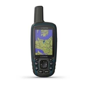
Today, many people confuse the GPS available on a smartphone that requires a cell phone tower signal with that of a handheld GPS unit or one in a car (such as Sirius radio or GPS navigation) that works anywhere directly from satellites. There is a big difference, because once you are out in the woods or in rural areas, cell towers are few and far between. This has spawned a large industry of handheld recreational GPS units from companies such as Garmin and Magellan that can be dropped, submerged in water, and otherwise abused, but still work. Try that with a smartphone!
GPS handheld receivers use signals received from a network of satellites, which also communicate with ground stations. Using very accurate clocks, receivers calculate their distance from the satellites by the amount of time each signal takes to travel from the satellite to the antennae in the receiver. The receiver is able to calculate its location using the signals from at least four satellites. Most mid-priced units ($150 - $400) have a 10-15 ft. accuracy or less, and can access 8 or more satellites. More expensive units with advanced technology and a separate antenna can be accurate to inches or less. Your unit will give you an estimate of the error in its current reading.
GPS is useful for finding points (known as waypoints) and lines of travel made up of waypoints (known as tracks) that can be used to calculate distance and acreage. Longitude and latitude data for a certain point can easily be stored as a waypoint on the unit. Lines between waypoints, called routes, are also easy to make just by connecting the dots. Tracks are lines of points automatically recorded at a set interval. Finding a stored waypoint once you’re in the field is easy. Just select the waypoint you’re looking for (usually by pressing a “GoTo” button) and a screen with an arrow will show you which way to go.
For the woodland owner, forester, hiker, camper, deer hunter, or recreationalist, handheld GPS receivers allow the marking of stream crossings, deer stands, roads & trails, emergency locations, and a host of other purposes. For the woodland owner, GPS can allow you to create an accurate map of your property’s corners and boundaries, along with roads, structures, and any other features you wish to add.
A handheld GPS receiver is most useful when utilized with computer software. Information on the receiver can be uploaded to a computer and mapped. You can also locate waypoints on aerial photographs on computer software, transfer it to the GPS receiver, and travel to that location. All this can save a lot of time in the woods. University of Maryland Extension did extensive training using Garmin MAPGPS 76 units over a decade ago and the training documents are still available at go.umd.edu/woodland. They still have some educational value since most of the GPS functions on Garmin units have not changed greatly.
What you do with your GPS data is dependent on the software you choose. Fortunately, there is a variety of free or low-cost software that comes with geo-referenced aerial photographs. EasyGPS is a good place to start. It is easy to use and aerial photographs are available for a nominal annual or monthly fee. If you have not tried a handheld GPS receiver, now is a good time to try. The accuracy of the units has improved greatly and pricing has become more competitive.