
Finding Tax Account ID numbers using Real Property Data Search (SDAT)
Introduction
Maryland Nutrient Management Regulations require that tax account identification number (or numbers) for all tax maps and farmed parcels are included in a nutrient management plan. When a tax bill or assessment for a property is not readily available, the Real Property Data Search website can be used to identify tax account ID numbers.
Using the Real Property Data Search
Instructions
Follow these steps to find the tax account ID number for a property.
- Step 1: Access the Maryland Department of Assessments and Taxation Real Property Data Search website at:
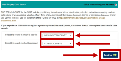
http://sdat.dat.maryland.gov/RealProperty/Pages/default.aspx Step 2: Use the drop down menu to select the county in which the property is located. In the second drop down menu, select “Street Address.” Then click on “Continue”.
Step 3: If you know the street number of the property in question, enter it into the Street Number box. If you do not know the street number, leave this box blank.
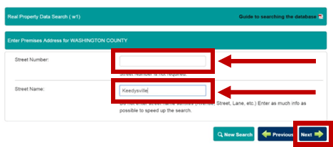
Enter the street name into the Street Name box. Type only the proper name. Do not include “Road,” “Drive,” “Street,” etc. Once completed, click on “Next”.
Step 4: If you were able to enter a street number, the tax account ID information will be displayed. Skip to Step 5.
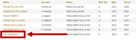
If you entered a street name only, a list of all of the properties on the street will be displayed. Look for the last name of the property owner and click on it to view the property information.
In the example below, the MD University is the property owner so we will click that name.
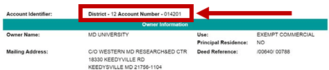
Step 5: The Account Identifier will be displayed in the upper left part of the page. It will be displayed as a district code and account number. The total tax account ID number includes a County Code, District Code, and Account Number. Identify the County Code from the table below these instructions and include this as part of the tax account ID number. The full account ID number for the property in the example is 2212014201.
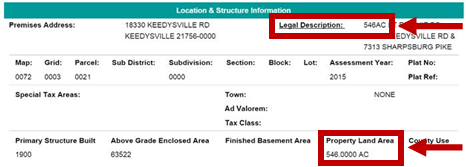
Step 6: The total acreage of the property is also required in a nutrient management plan. Total acreage is located in the “Location & Structure Information” section of the page under “Legal Description” or under “Property Land Area”.
County Codes
| County | County Codes |
|---|---|
| Allegany | 01 |
| Anne Arundel | 02 |
| Baltimore City | 03 |
| Baltimore | 04 |
| Calvert | 05 |
| Caroline | 06 |
| Carroll | 07 |
| Cecil | 08 |
| Charles | 09 |
| Dorchester | 10 |
| Frederick | 11 |
| Garrett | 12 |
| Harford | 13 |
| Howard | 14 |
| Kent | 15 |
| Montgomery | 16 |
| Prince George’s | 17 |
| Queen Anne’s | 18 |
| St. Mary’s | 19 |
| Somerset | 20 |
| Talbot | 21 |
| Washington | 22 |
| Wicomico | 23 |
| Worcester | 24 |
ANMP Plan Writing Tools Navigation
-
ANMP Farm and Field Information >
ANMP Farm and Field Information > -
ANMP Soil and Tissue Sampling and Testing >
ANMP Soil and Tissue Sampling and Testing > -
ANMP Manure Sampling, Testing, and Quantity Estimation >
ANMP Manure Sampling, Testing, and Quantity Estimation > -
ANMP Generating Recommendations >
ANMP Generating Recommendations > -
ANMP Compiling, Reviewing, and Relevant Documents for the NMP >
ANMP Compiling, Reviewing, and Relevant Documents for the NMP > -
ANMP Plan Writing Tools >
ANMP Plan Writing Tools >