FS-2022-0645 | May 2023
Losing Your Trees to the Sea?
Options for Maryland's Coastal Woodland Owners

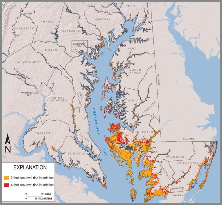
Over a third of Maryland’s Lower Eastern Shore is forested land, where loblolly pine is more common than mixed oaks and other hardwoods. The woodlands in low-lying areas of the Lower Shore may be at risk from flooding and saltwater intrusion as sea levels rise (Fig. 1). Saltwater intrusion occurs when tides and storms carry salty seawater into soil, surface water, and groundwater. Rising sea levels are making this problem worse by allowing saltwater to reach further inland. Higher seas can also cause higher groundwater levels and reduced drainage in low-lying coastal areas, producing wetter conditions. These processes can lead to conditions that are too wet and salty for woodlands to thrive.
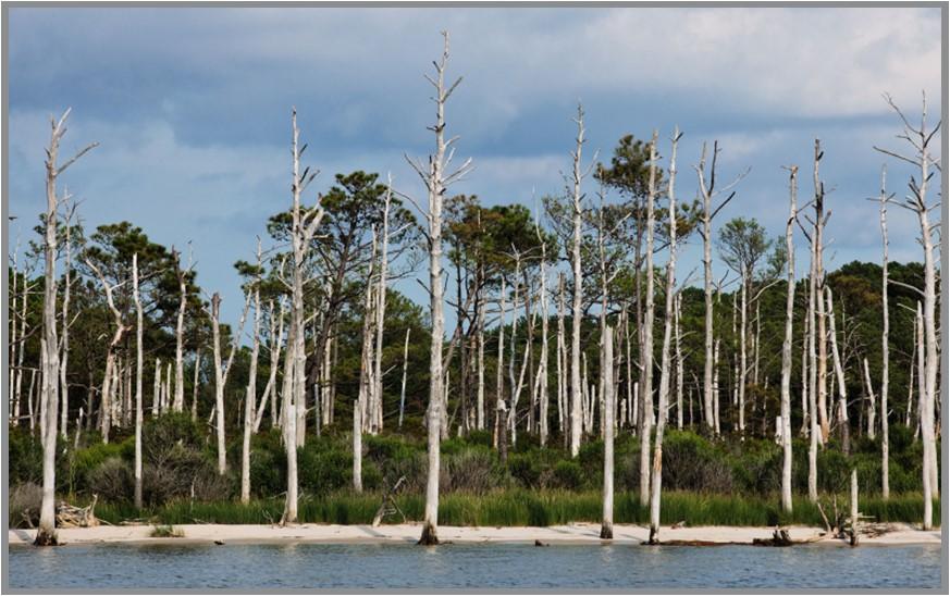
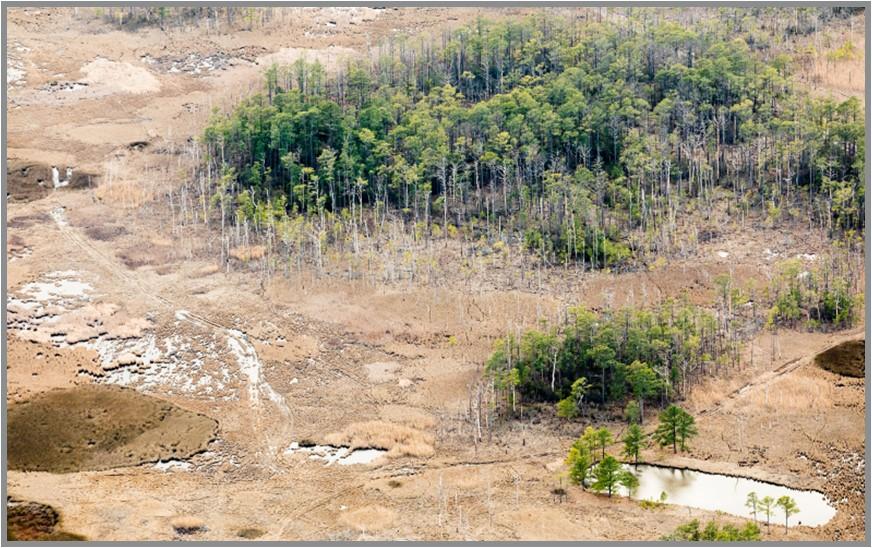
Many trees are known to be resilient and tolerate some intermittent flooding and saltiness (Gibson et al. 2021). However, chronically wet and salty conditions can cause stress and can limit growth rates and tree regeneration. Stress caused by flooding and saltwater intrusion can also weaken trees and make them more vulnerable to pests, such as the southern pine beetle (Maryland Department of Agriculture, n.d.). Seedlings are more vulnerable to flooding and salinity stress than mature trees. In some coastal areas in Maryland, woodlands are failing to regrow because of increased flooding even when there are abundant seedlings and an open canopy (Saxby, Griswold, and Wicks, 2013). Sufficiently stressful conditions also cause mature trees to die. When the ground is too wet and salty for trees to survive, stands of dead trees, known as “ghost forests,” can form (Fig. 2). As saltwater encroaches and creates conditions unsuitable for trees, coastal woodlands can transition to tidal saltmarsh (Fig. 3).


What is a saltmarsh?
A saltmarsh is a coastal wetland that is flooded with saltwater during high tides. Saltmarsh habitats can provide many important services, such as protecting shorelines from erosion and improving water quality by filtering out excess nutrients.
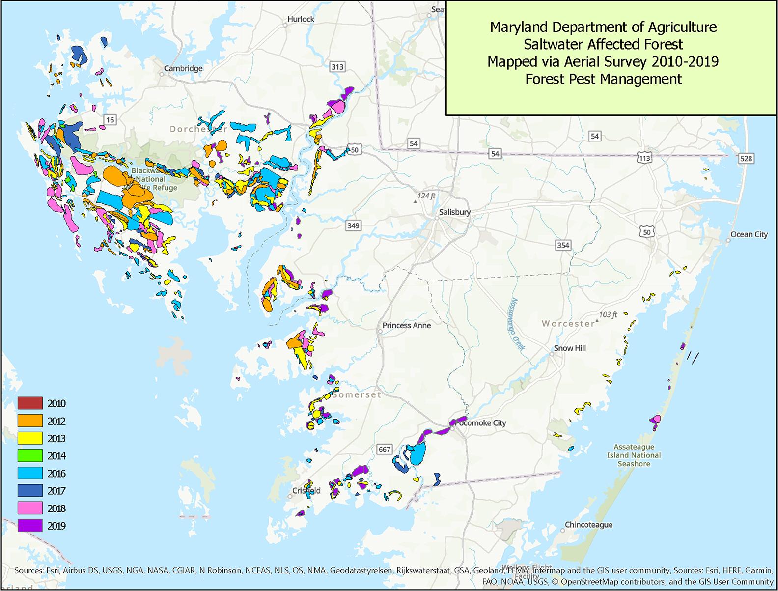
Increasingly wet and salty conditions are impacting Maryland’s woodlands. Every year the Maryland Department of Agriculture identifies areas of forestland on the Lower Eastern Shore that are newly or more severely affected by saltwater intrusion (Fig. 4). In 2021 they found that 84,381 acres of forest were affected by saltwater intrusion (Maryland Department of Agriculture, 2022). Damage was observed across the Lower Shore, with the majority of affected forest in Dorchester County (Table 1). In the future, previously unaffected woodlands also will be impacted by saltwater intrusion as the sea continues to rise.

| County | Acres of forest affected by saltwater intrusion |
|---|---|
| Dorchester | 60,575 |
| Somerset | 8,249 |
| Wicomico | 9,799 |
| Worcester | 5,758 |
The majority of Eastern Shore forests are privately owned (Lister, 2017). Individuals and families own woodlands for many different reasons, including harvesting trees for income, living in a home in the woods, or enjoying recreational activities such as walking or hunting. However, some owners are seeing wetter and saltier conditions that may interfere with their goals for their land. As conditions continues to change, coastal woodland landowners:
- may not be able to harvest trees if the ground is too wet;
- may not be able to replant desired trees if conditions are too wet and salty;
- may see changes in wildlife presence and vegetation type as woodlands turn into saltmarsh (including increased presence of invasive species);
- may lose opportunities for some recreational activities.
Landscape changes caused by sea level rise are difficult or impossible to prevent or reverse. However, some options may be available if your woodlands are affected.
Maryland-Delaware Master Loggers report observing the following changes in forests on the Eastern Shore:
- More dead or dying trees and ghost forests
- More flooding by seawater and more standing water on the land
- Soils that are wet longer
- Increased presence of wetland plants
Results from survey of Maryland-Delaware Master Loggers conducted January 2022.
Are your woodlands being affected?
You can look for several signs to determine if coastal flooding and saltwater intrusion may be an issue in your woodland. Keep in mind that saltwater can be carried inland by ditches, groundwater, and storms to impact land that is not directly along the shoreline.
Indicators include:
- increased presence of marsh plants, such as the common reed (Phragmites australis), or shrubs such as the southern wax myrtle (Myrica cerifera);
- new areas with standing water or the ground staying wet for longer periods;
- signs of reduced tree health and vigor, including increase in insect problems, sparse crown, low growth, mortality, short needles length in pines, small foliage in hardwoods, overall appearance of poor health, salt burning, and browning of leaves (Gibson et al. 2021);
- dying young trees and no recruitment of new trees (Kirwan and Gedan, 2019).
You can also determine if your land is impacted by saltwater by testing the soil salinity. Soil testing laboratories can determine the salinity of soil samples by measuring the electrical conductivity (EC) of the saturated extract (an extraction of one-part soil to one-part water). Because salts increase the ability of a solution to conduct electricity, high EC values indicate higher salinity levels. EC is commonly expressed as deciSiemens per meter, or dS/m. Soils with EC values greater than 4.0 dS/m are considered moderately saline and may have an adverse effect on tree health (Table 2) (Gibson et al. 2021). Soils with EC values above 8.0 dS/m are associated with severe salinity stress in trees and are generally unsuitable for commercial forestry (Table 2) (Gibson et al. 2021). For more information on collecting and analyzing soil samples, reach out to your local extension office or directly contact a soil testing lab (Traunfeld, 2023).
| Salinity classification | Electrical conductivity (EC) | Impacts of salinity on woodlands |
|---|---|---|
| Nonsaline | 0-2.0 dS/m |
|
| Slightly saline (sporadic, episodic salinity events) | 2.0-4.0 dS/m |
|
| Moderately saline (recurring episodic events) | 4.0-8.0 dS/m |
|
| Strongly saline (low chronic salinity) | 8.0-16.0 dS/m |
|
| Extremely saline (high chronic salinity) | >16.0 dS/m |
|
What can a landowner do?
Landscape changes caused by sea level rise cannot be reversed or easily prevented. However, a range of options may be available if your woodland is affected by coastal flooding and saltwater intrusion. Potential options include:
- Continue monitoring environmental conditions – If you observe signs of coastal flooding and saltwater intrusion or you are concerned about them becoming a problem on your land, monitoring tree health, soil salinity, water levels, and flood conditions can help inform when you should take further action. Slightly or moderately saline conditions will likely affect seedlings before mature trees are impacted. Talking to your neighbors about changes they see on their properties may also help indicate if your land may be affected soon.
- Assess drainage and maintain ditches – Ditches are used to drain low-lying land throughout the Eastern Shore. However, the capacity of ditches to carry away excess water is reduced as sea levels rise and saltwater may travel inland through ditches during storms and high tides. Vegetation and sediment can block ditches and prevent saltwater brought in by storms from flowing back out to the sea. Regularly cleaning out ditches can help ensure they continue to function properly. Tide gates can also limit the flow of saltwater upstream into ditches, but can be costly to install and maintain.
- Plant salt-tolerant trees – Some tree species have a higher tolerance for saline conditions. Consider planting tree species such as loblolly pine, red cedar, persimmon, hackberry, black locust, and honey locust in areas with salty soils (Fox and Koci, 2021). However, increasingly wet conditions can still be a problem for these species and salt-tolerant trees may be a temporary solution as seas continue to rise and coastal woodlands transition to saltmarsh.
- Harvest trees before they deteriorate or the land is too wet – If you intend to harvest timber, it is important to do so before the ground is consistently wet. Harvesting trees on flooded land is often not a cost-effective option and can require extra permits and specialized equipment most Eastern Shore loggers do not have, such as a trac cutter with dual wheels. Most loggers are unable or unwilling to work on sites with standing water but may be able to harvest timber during drier periods. If trees must be harvested on wet ground, laying mats can help prevent rutting and protect wet soils. Because there is a limited market for dead trees, it is recommended to harvest trees before wet and salty conditions cause them to deteriorate. Keep in mind that special regulations may apply to harvesting trees in or near wetlands or tidal areas. Work with a licensed forester to develop a plan to appropriately time a tree harvest and ensure you are following current regulations. A logger is unlikely to accept a proposal to harvest trees on a property of less than five acres in size. Consider working with your neighbors to increase the acreage to be harvested across multiple properties.
- Consider opportunities for generating income besides harvesting timber – Harvesting timber may cease to be feasible as seas rise and coastal woodlands become wetter and saltier. However, other opportunities may be available to generate income:
- Conservation easements – A conservation easement is a voluntary legal agreement that limits the use of land in order to protect its conservation values. In return, landowners receive a direct payment or compensation in the form of tax incentives. Woodlands affected by coastal flooding and saltwater intrusion may be eligible for some federal and state conservation easement programs (Appendix A); however, these programs are not specifically designed for land impacted by sea level rise. In addition, easements can be competitive due to limited funding and the application process can be time-intensive. A local land trust, such as the Eastern Shore Land Conservancy or the Lower Shore Land Trust, can provide more information about conservation easements.
- Hunting leases – Land on the Eastern Shore that is transitioning from woods to saltmarsh may be desirable for hunting sika deer, white tail deer, wild turkey and/or waterfowl. Optimal land to lease for hunting should be at least 25 acres in size, have game species present, and water or road access. Before leasing land to hunters, landowners should conduct a wildlife inventory survey, obtain liability insurance, develop a written lease, and advertise hunting opportunities. Further information on leasing land for hunting is available from University of Maryland Extension (Kays, 2003 and 2008).
- Selling land – It may be challenging to find a buyer for land that is chronically wet, but some hunting clubs may be interested.
- Facilitate the transition to saltmarsh habitat – Allowing or encouraging woodlands to transition to saltmarsh can create habitat for wildlife and help protect coastal areas from flooding and erosion. Outdoor recreational activities, such as hunting, fishing, and boating, can also be enjoyed in saltmarshes. The conversion of woodlands to marsh may be unavoidable, but some strategies can help facilitate this transition and enhance habitat quality:
- Create living shorelines – A living shoreline uses natural materials such as plants, sand, or rock to protect and stabilize the shoreline. These techniques can prevent erosion while allowing saltmarsh habitat to naturally migrate inland as sea levels rise. The Maryland Department of Natural Resources can provide information and assistance on living shoreline projects (Maryland Department of Natural Resources, n.d.).
- Replace dead trees with native flood- and salt-tolerant shrubs and grasses – Planting native saltmarsh plants can help stabilize shorelines and reduce erosion. See the U.S. Fish and Wildlife Service’s Native Plants for Wildlife Habitat and Conservation Landscaping: Chesapeake Bay Watershed for information on appropriate species to consider (Slattery, Reshetiloff, and Zwicker, 2003).
- Manage invasive species – As coastal forests transition to saltmarsh, the invasive marsh plant Phragmites australis, or common reed, typically outcompetes native plant species that provide key habitat for saltmarsh birds and animals (Allen and Strain, 2013). Herbicide application and physical control (mowing, burning, and/or smothering with a plastic tarp) can help limit Phragmites. However, Phragmites is difficult to control and landowners may need to obtain permits or authorizations before applying herbicides or implementing physical control measures (Critical Area Commission for the Chesapeake and Atlantic Coastal Bays, 2020). Phragmites can also build soil elevation and consume water, which may help slow the impacts of saltwater intrusion. Removing Phragmites may destabilize sediments and result in additional shoreline erosion.
- Remove dead trees – Saltmarsh birds prefer open space for nesting. Removing dead or dying trees in areas transitioning to saltmarsh can increase the available bird habitat (Lerner et al. 2013). However, retaining some dead trees can provide habitat for bats, insects, and other wildlife.
Decisions about which option to pursue may be complex and will depend on your objectives and priorities for your woodland. When evaluating potential options, consider the degree of salinization, your long- and short-term goals, and property-specific factors, such as property size, location, accessibility, and wildlife. Keep in mind that the best management strategy may change over time as seas rise and saltwater continues to encroach.
If you suspect saltwater is impacting your woodland, contact your local extension office or your county’s state forestry office for more information about management options:
- University of Maryland Extension county offices: https://extension.umd.edu/locations
- Maryland Forest Service county and regional offices: https://dnr.maryland.gov/forests/Pages/contacts.aspx
Advice from Maryland-Delaware Master Loggers for woodland landowners experiencing flooding or rising saltwater:
- Check if ditches are draining well – improve and maintain existing ditches to enhance drainage or construct new ditching where possible.
- If you do want to harvest, contact the local Soil Conservation District for the permitting process in your county. There is substantial planning involved and the process can be lengthy, so start early.
- Cut the timber when the land is dry.
- Don’t plan on being able to establish another stand of timber after harvesting.
- Contact the Maryland Department of Natural Resources for advice.
- Consider a hunting lease or selling the property to buyers interested in wildlife or other values.
Results from survey of Maryland-Delaware Master Loggers conducted January 2022.
Acknowledgments:
We would like to thank UMCP Environmental Science and Policy students Evan Brooks, Siena Fouse, Justin Lee, Zach Lee, Mathew White, and Safah Wyne and their instructor, Joanna Goger. This team completed a capstone project in Fall 2020 on options for coastal forest landowners that informed the development of this factsheet. We would also like to thank Matt Hurd (MD Forest Service) for feedback on an earlier draft, Heather Disque (MD Department of Agriculture) for maps and data on salt-impacted forestland, and David Satterfield (Eastern Shore Land Conservancy) for contributions to Appendix A.
References:
- Allen, Jenny and Daniel Strain. 2013. Aquatic Invasive Species in the Chesapeake Bay: Phragmites (Common Reed). Maryland Sea Grant, Publication UM-SG-PI-2013-03. https://www.mdsg.umd.edu/sites/default/files/files/Phragmites_AIS%20brief_PI-2013-03.pdf
- Critical Area Commission for the Chesapeake and Atlantic Coastal Bays. 2020. Phragmites: Considerations for Management in the Critical Area. DNR 10-091420-250. https://dnr.maryland.gov/criticalarea/Documents/Phragmites-Fact-Sheet-Final.pdf
- Dubow, Jason, and Deborah Herr Cornwell. 2019. Maryland’s Plan to Adapt to Saltwater Intrusion and Salinization. Maryland Department of Planning. https://planning.maryland.gov/Documents/OurWork/envr-planning/2019-1212-Marylands-plan-to-adapt-to-saltwater-intrusion-and-salinization.pdf
- Fox, Laurie and Joel Koci. 2021. Trees and Shrubs that Tolerate Saline Soils, Salt Spray and De-icing Salts. Virginia Cooperative Extension, Publication 430-031. https://www.pubs.ext.vt.edu/430/430-031/430-031.html
- Gibson, Nancy, Steven McNulty, Chris Miller, Michael Gavazzi, Elijah Worley, Dan Keesee, and David Hollinger. 2021. Identification, Mitigation, and Adaptation to Salinization on Working Lands in the U.S. Southeast. General Technical Report SRS-259. Asheville, NC: U.S. Department of Agriculture Forest Service, Southern Research Station. https://www.fs.usda.gov/research/treesearch/61766
- Kays, Jonathan. 2003. Rural Enterprise Series: Hunting Lease Enterprise. Maryland Cooperative Extension, RES-07. https://extension.umd.edu/sites/extension.umd.edu/files/2021-03/RES_07HuntingLease.pdf
- Kays, Jonathan. 2008. Landowner Liability and Recreational Access. Maryland Cooperative Extension, EB-357. https://extension.umd.edu/sites/extension.umd.edu/files/publications/EB357_LandownerLiabilityRecAccess.pdf
- Kirwan, Matthew L. and Keryn Gedan. 2019. “Sea-level driven land conversion and the formation of ghost forests.” Nature Climate Change. 9:450-457.
- Lerner, J.A., D.R. Curson, M. Whitbeck, and E.J. Meyers. 2013. Blackwater 2100: A strategy for salt marsh persistence in an era of climate change. The Conservation Fund (Arlington, VA) and Audubon MD-DC (Baltimore, MD). https://www.conservationfund.org/images/projects/files/Blackwater-2100-report_email.pdf
- Lister, Tonya. 2017. Forests of Maryland, 2016. Resource Update FS-136. Newtown Square, PA: U.S. Department of Agriculture, Forest Service, Northern Research Station. https://www.fs.usda.gov/nrs/pubs/ru/ru_fs136.pdf
- Maryland Department of Agriculture. 2022. Maryland Department of Agriculture FY2022 Annual Report. https://mda.maryland.gov/Documents/MDA_AR_2022_FINAL4.pdf
- Maryland Department of Agriculture. (n.d.) Southern Pine Beetle, Dendroctonus frontalis. Maryland Department of Agriculture Eastern Shore Regional Office. Accessed April 19, 2023. https://mda.maryland.gov/plants-pests/Documents/southernpinebeetle.pdf
- Maryland Department of Natural Resources. (n.d.) “Living Shorelines.” Accessed April 7, 2022. https://dnr.maryland.gov/ccs/pages/livingshorelines.aspx
- Saxby, Tracey, Marcus Griswold, and Caroline Wicks, eds. 2013. Helping your woodland adapt to a changing climate. University of Maryland Center for Environmental Science. https://ian.umces.edu/site/assets/files/11060/helping-your-woodland-adapt-to-a-changing-climate.pdf
- Slattery, Britt E., Kathryn Reshetiloff, and Susan M. Zwicker. 2003. Native Plants for Wildlife Habitat and Conservation Landscaping: Chesapeake Bay Watershed. U.S. Fish & Wildlife Service, Chesapeake Field Office, Annapolis, MD. 82 pp. http://dnr.maryland.gov/criticalarea/Documents/chesapeakenatives.pdf
- Traunfeld, Jon. 2023. “Soil Testing and Soil Testing Labs.” University of Maryland Extension. https://extension.umd.edu/resource/soil-testing-and-soil-testing-labs
Appendix A:
State and federal conservation easement programs for coastal woodland owners to consider.
| Program | Eligibility | Return | Length of Term | More Information |
|---|---|---|---|---|
| Maryland Conservation Reserve and Enhancement Program (CREP) – Easement Option | Land must have an existing CREP contract through Natural Resource Conservation Service in order to be eligible. Landowners required to agree to maintain CREP practices after the expiration of CREP contract in order to be eligible. For each acre of CREP contract acres, landowners may enroll 10 acres of woodland or wetland habitat. CREP easements may not be available in every county. No minimum land size requirement. |
Program payment is determined through an Easement Valuation System (EVS) designed by the State of Maryland. CREP Sponsors pay 100% of easement value determined through EVS. | Perpetual | Program Website: https://dnr.maryland.gov/land/Pages/crep.aspx |
| Maryland Environmental Trust (MET) Conservation Easement Program | Proposed area must meet at least one of the following conservation purposes:
Minimum land size of 25 acres. |
No direct payment because MET only accepts donated easements. Tax benefits include federal and state income tax deductions worth the easement’s appraisal value as a charitable gift; lower estate and inheritance taxes; and a 15-year state and local property tax exemption on undeveloped land. |
Perpetual | Program Website: https://dnr.maryland.gov/met/pages/land_conservation.aspx |
| Maryland Forest Legacy Program | Land must lie within a designated acquisition boundary, known as a Forest Legacy Area. Properties must have development rights which can be retired in order to be eligible. Properties must be a minimum of 75% forested, with the remainder being in a compatible land use, such as agriculture. Properties which contain forests of significant ecological value will be prioritized for funding. | Program payment is determined through negotiation. Cost is split between federal and non-federal sources, with up to 75% of project costs coming from federal funds and at least 25% from state or local funds or from land donated by the landowner. |
Perpetual | Program Website: https://dnr.maryland. gov/forestspagesprogra mapps/forestlegacy.aspx |
| Maryland Program Open Space | Land is evaluated using an ecological score (based on designated “Targeted Ecological Areas” and a green infrastructure evaluation) and a people score (based on recreational, cultural, historical, and water access purposes). Some coastal land on the Lower Eastern Shore is in Targeted Ecological Areas. No minimum land size requirement. |
Direct payment after land is appraised in exchange for entering the easement agreement. | Perpetual | Program Website: https://dnr.maryland.gov/land/Pages/ProgramOpenSpace/Program-Open-Space-Stateside.aspx |
| Maryland Rural Legacy Program | Land must lie within a designated acquisition boundary, known as a Rural Legacy Area. Properties must have development rights which can be retired in order to be eligible. Properties which contain significant agricultural and natural resources are prioritized for funding. No minimum land size requirement. |
Program payment is determined either through an Easement Valuation System (EVS) negotiated with the Rural Legacy Sponsor or through appraisals. Rural Legacy Program pays 100% of easement value, regardless of the valuation determining system. | Perpetual | Program Website: https://dnr.maryland.gov/land/pages/rurallegacy/home.aspx |
| Local Land Trust Donated Conservation Easement Programs (Eastern Shore Land Conservancy, Lower Shore Land Trust) | Must meet at least one of the following conservation purposes:
Minimum land size may vary and is often flexible for exceptional conservation attributes. |
No direct payment; donated easements have potential for Federal tax benefits. Tax benefits include federal income tax deductions worth the easement’s appraisal value as a charitable gift, as well as lower estate and inheritance taxes. |
Perpetual | Program Websites: https://www.eslc.org/land/ https://www.lowershorelandtrust.org/land |
| Agricultural Conservation Easement Program (ACEP): Wetland Reserve Easements (WRE) | Site must have an agricultural history (such as forest production) and the wetland hydrology must have been altered or degraded (through ditching, for example). No minimum land size requirement, but larger easements tend to rank higher. |
Permanent: Payment of 100% of the easement value for the purchase of the easement and 75-100% of restoration costs 30-year: Payment of 50-75% of the easement value for the purchase of the easement and 50-75% of restoration costs |
Perpetual or 30-year | Local NRCS offices can provide information and assistance: https://offices.sc.egov.usda.gov/locator/app?state=MD |
| Readiness and Environmental Protection Integration Program (REPI) | Land must lie within a designated acquisition boundary for a military installation. REPI’s focus is on reduced development to protect the military mission of the impacted installation. Additional focus given to achieving conservation objectives in and around the installation, including resilience to climate change and protection of threatened and endangered species. No minimum land size requirement. |
Program payment may vary, depending on the installation agreement with REPI. Payment ranges from 50% to 100% of appraised easement value. | Perpetual | Program Website: https://www.repi.mil/ |
| U.S. Fish and Wildlife Service (USFWS) –North American Wetland Conservation Act (NAWCA), Section 6 funding, Refuge system protection | The USFWS funds conservation easement projects focuses on the protection and restoration of strategic wildlife and habitat resources, especially as relates to threatened and endangered species and habitat types. Prioritization for funding will vary depending on grant Program. No minimum land size requirement. |
Program payment 100% of easement value as determined through appraisal. | Perpetual | Program Website: https://www.fws.gov/service/north-american-wetlands-conservation-act-nawca-grants-us-standard |
KATE MCCLURE, PH.D
mcclure@umd.edu
AGNES KEDMENECZ
This publication, Losing Your Trees to the Sea?: Options for Maryland’s Coastal Woodland Owners (FS-2022-0645) is a part of a collection produced by the University of Maryland Extension within the College of Agriculture and Natural Resources.
The information presented has met UME peer-review standards, including internal and external technical review. For help accessing this or any UME publication contact: itaccessibility@umd.edu
For more information on this and other topics, visit the University of Maryland Extension website at extension.umd.edu
University programs, activities, and facilities are available to all without regard to race, color, sex, gender identity or expression, sexual orientation, marital status, age, national origin, political affiliation, physical or mental disability, religion, protected veteran status, genetic information, personal appearance, or any other legally protected class.